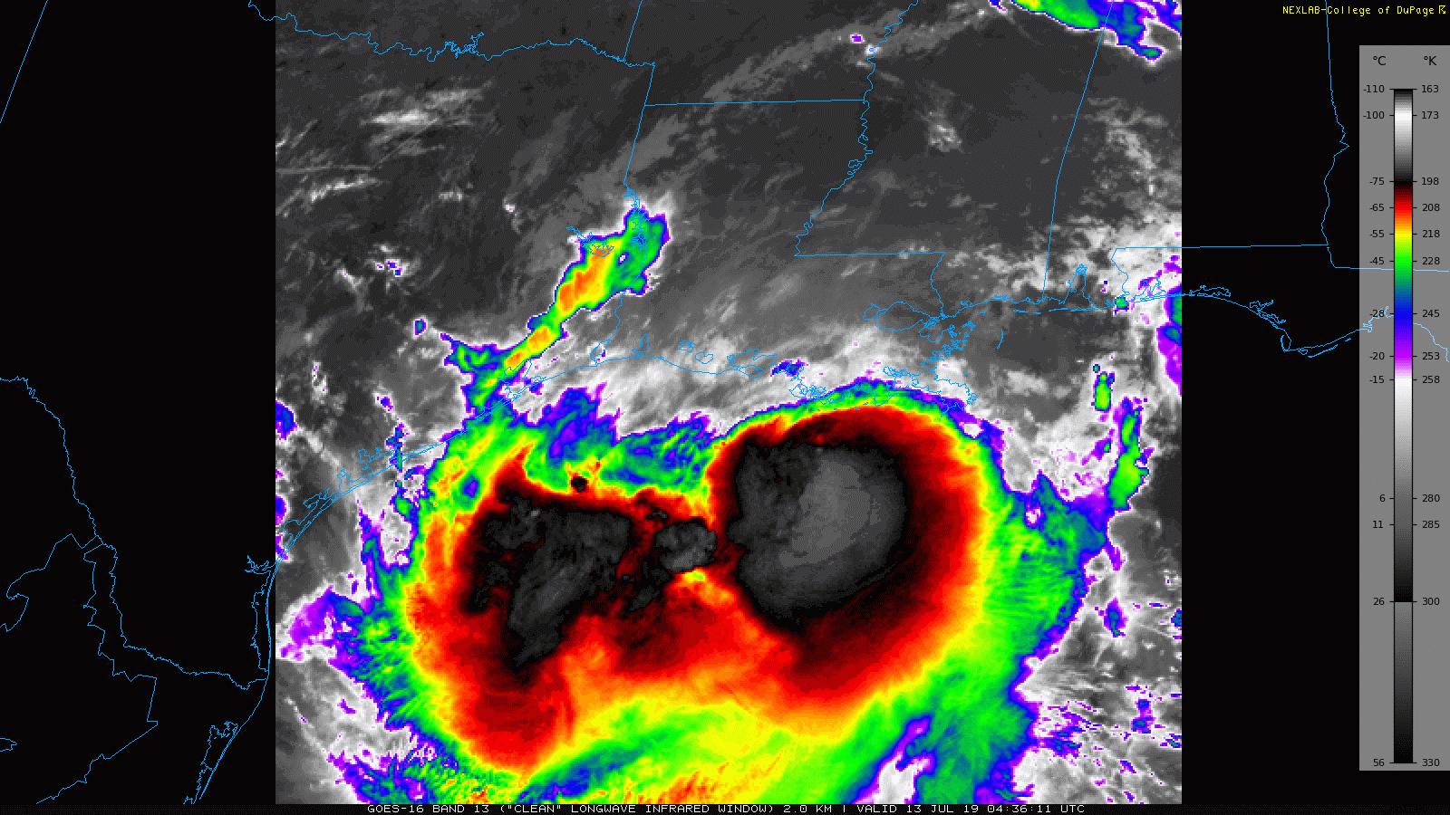
Tropical Storm Barry is about 75 miles south of Morgan City, LA per the 10 p.m. NHC advisory. Barry continues to track very slowly towards the west-northwest, but a turn towards the northwest, then north is expected during the next 12-24 hours. On satellite, Barry is looking a little better organized this evening. Earlier today, the center of circulation was largely exposed with little in the way of deep convection around it. Now, the convection is trying to wrap around the center, and infrared satellite indicates that cloud tops are cooling -- a sign that the convection is getting more intense.
 |
| GOES-16 Channel 13 "Clean Infrared" image of Tropical Storm Barry (source: College of DuPage) |
Despite the northern side being almost totally devoid of convection, gusty winds have made their way onto the Louisiana coast.
New Orleans,
Houma (Terrebonne Parish), and
Patterson (St. Mary Parish) have all reported tropical storm force wind gusts in the past hour. Even
Lafayette has been gusting over 30 mph during the past hour. Expect winds to ramp up slowly through the night and into Saturday morning as the center approaches the coast.
Little change was made to the forecast at the 10 p.m. advisory, with the center still expected to make landfall late Saturday morning or early afternoon as a category one hurricane. The suite of evening model runs is largely unchanged as well, with most of the major models lying very near the NHC forecast track. It seems at this point, that Barry will make landfall near Atchafalaya Bay, track north along the U.S. 90 corridor, and very near or just east of Lafayette. This would put the strongest winds across coastal portions of south-central Louisiana.
 |
| Wind Threat graphic from NWS Lake Charles, LA. While the graphic shows "73-110 mph", we are highly unlikely to see wind gusts exceeding 100 mph. This is just the fixed scale used by this particular graphic. |
The heaviest rains are expected to be to the east of where the center ultimately tracks. Based on the latest forecast, this would put the heaviest rains roughly along a corridor from Houma to Baton Rouge, where 12-18 inches of rainfall appear likely. Some spots in and around this corridor could receive in excess of 24 inches of rainfall. This has the potential to lead to life-threatening and devastating inland flooding.
 |
| Forecast rainfall totals graphic from NWS Lake Charles, LA. |
It is important to note that because the heaviest convection lies to the south of the center, the heavy rains will not start to really ramp up until Saturday afternoon. Thereafter, they will continue into Saturday night and Sunday as well. This is expected to be a long-lasting extreme rainfall event, with heavy rains likely to fall for a solid 48 hours across the affected areas.
One of the reasons it is difficult to pinpoint exactly where the heaviest rains will fall is it depends on where the heavy feeder bands set up. The forecast model graphic below shows what the structure of Tropical Storm Barry may look like by Saturday night. Note the very heavy band of precipitation extending from southeast of the center, back to the southwest off the Louisiana coast. Bands such as this one can produce extremely heavy rainfall rates, in some cases, as much as 2-3 inches per hour. It is when feeder bands like this train over the same area for an extended period of time that very high rainfall totals are realized in tropical cyclones. A word of caution: do not focus on exactly where the model graphic below shows this feeder band setting up. The position is subject to change, and will likely be different than exactly what is shown here. The graphic below is just to illustrate how we may see very heavy rainfall totals come to fruition during the next 48 hours. The official rainfall forecast is in the graphic above.
 |
| 3 km NAM forecast model valid at 12:00 a.m. Sunday morning (i.e. Saturday going into Sunday). Image source: College of DuPage. |
So at the risk of sounding like a broken record, the rainfall will be the story with this tropical cyclone. There is not much difference between a 70 mph tropical storm, and a 75 mph category one hurricane. Do not be overly concerned with the intensity at landfall, or the exact track of the center. At this point, confidence is pretty high that coastal south-central Louisiana (especially Lafayette down to Morgan City) will see the highest winds, with heavy rain likely to fall near and to the east of this corridor (over towards Baton Rouge down to Houma). It's going to be a long 48 hours in South Louisiana...


Comments
Post a Comment