Posts

Showing posts from December, 2019

Photo of the Week: First Tornado

Image
This is sorta a weather blog isn't it? It's about time I share a weather photo. For this week's photo of the week, my first tornado! This tornado was spotted near Groom, TX along Interstate 40 on a storm chase on April 22, 2010. This particular tornado was only on the ground for a few seconds, and was rated EF0 since it basically did not cause any damage. Meteorology : A large cutoff low was noted on 500 mb analysis, with a surface dryline in place over the Texas Panhandle. The  morning SPC convective outlook  had a large Slight Risk area over much of the High Plains, including a 10% significant tornado probability over the Texas Panhandle. It should be noted that under today's SPC outlook conventions, this would have been an "Enhanced Risk". The outlook text noted that supercells capable of very large hail were likely to develop along the dryline, with the tornado risk increasing during the early evening hours as a low-level jet developed. At 2:35 p.m. C
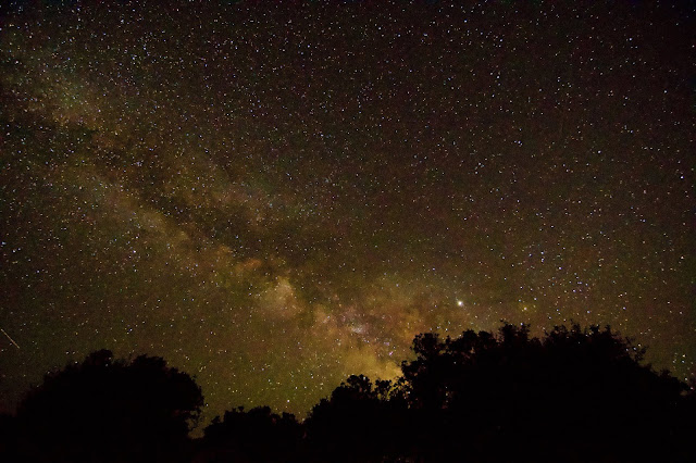
Photo of the Week: Milky Way Over Black Canyon

Image
For this week's installment of "Photo of the Week", I am featuring what is probably to date, my best Milky Way shot. This photo was taken last June from the South Rim Campground at Black Canyon of the Gunnison National Park , Montrose County, Colorado. The photo was taken using my Nikon D3300 DSLR equipped with a Tokina 11-18 mm wide-angle lens. I used a wide aperture (f/2.8), short focal length (11 mm), kicked the ISO up to 6400, and did a 20-second exposure. My advice to photographers attempting a similar shot: don't focus overly on what my settings were, or what someone else's were. While those settings may be a good starting point, some trial and error (and I mean, a lot of error) will be required. I think I initially started with a lower ISO, and kicked it up higher to really get the deep space objects in the shot. I should also point out that this photo was minimally post-processed, except for perhaps some slight adjustments to the exposure. Using Stell

Photo of the Week: Independence Pass

Image
For my inaugural post on this new blog, I will kick off my "Photo of the Week" series with the cover photo to the new website. This photo was taken on the ascent up Independence Pass, Colorado in June 2019. State Highway 82 traverses Independence Pass, and is the second highest paved mountain pass in the U.S., reaching an elevation of 12,095 at the Continental Divide. Only Trail Ridge Road (U.S. Highway 34) in Rocky Mountain National Park is higher. Independence Pass connects Aspen on the west to Twin Lakes on the east. Several prominent high 14ers are visible from the pass including Mount Elbert (the highest point in Colorado at 14,440 feet) and La Plata Peak (14,361 feet). The highway typically opens to traffic the Thursday heading into Memorial Day Weekend, but opened late in 2019 after one of the snowiest winters in recent memory. Even in late June, snow was abundant above the treeline. Entering Independence Pass from Twin Lakes (east of the Continental Divide)